
|
Welcome! These pages feature trails run by the members of TrailDamage.com (why that name?), a club based in Colorado. Here you can find information about trails in Colorado, Utah, Arizona, California, Texas and Wyoming. Each trail page contains a description of the trail, as well as trail features like rock climbing, water crossings and mud. Pictures, maps, and Google Earth information (what is Google Earth?) are featured here, with many more pictures and movies within each Trail Report. Latest Trail Report: Sanborn Park Road on October 17, 2016
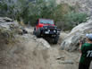
Trail run by Monica, Roger and Walt: The Last Ten Runs
Featured Member of the Month: Matt K.
Member Trail Recommendation Monica recommends Chivo Falls as one of our favorite Arizona trails (Pima County):
| Invite Only The only way to join the club is to be invited by a current club member. We have quite a few members! We're not the usual kind of 4x4 club -- there is a small fee for the year only if you go wheeling, and there are no required meetings. We're just a group of friends who get together as often as possible to run trails in the area. Trail Damage 2016 Winner
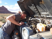
The best Trail Damage of 2016 went to Matt running Big Water Canyon on May 14th, 2016. He couldn't have been much farther from civilization when he stopped, opened his hood, and pulled out a belt. His Jeep didn't want to run at that point, so Frank towed him out. It took about seven hours, but he made it back to civilization. We don't have any 2017 contenders yet. See winners from previous years TrailDamage.com and Google We like what Google does with mapping and satellite imagery, so we use Google Maps and Google Earth to provide even more information about the locations of trails and obstacles. Google Maps make searching for trails easier in Colorado, Utah, Arizona, Wyoming, California and Texas. If you really want to see it before you get there, use the Google Earth Placemarks and Tracks found on the trail pages of this site to check out the terrain first. Get Stuff The 2017 wall calendar is available for purchase! This year, we're calling out some of our favorite images of trails and scenery from 2016, and there are many calendar options to choose from. You can also buy a bunch of stuff with the TrailDamage.com logo on it, like clothes and bags. We have a lot of DVDs from our early years, too, if you are looking for specific photos at high resolutions. Check it out! |


Copyright © 2002-2017 |
About |
Terms |
Contact |
Members |
|
 Twitter